The Right Address. Stories of Jews hiding in Occupied Warsaw


“Addresses — where did we get those addresses from? Someone once asked me that. I couldn't answer. Perhaps from little notes in gateways: ‘room for rent’? Oh no. More often — most often — through somehow branching networks of contacts with ‘trustworthy’ people. What I do know is that, whenever you went to such addresses, you could never be certain whether it was truly the right address or a trap, whether, when you left such an apartment, you would walk straight into the hands of the police, and whether the people there would be safe,” wrote Adina Blady-Szwajger (1917–1993), who, after leaving the Warsaw Ghetto, hid on the “Aryan side”.
What will you find on The Right Address historical map?
Historians estimate that, during various periods of the German occupation, as many as 27,000 Jews may have been hiding in Warsaw. They hid with the help of Polish men and women, other Jews, or on their own. They risked their lives — the German occupation authorities imposed the death penalty both for leaving the ghetto and for providing assistance to Jews.
On the historical map The Right Address. Stories of Jews hiding in Occupied Warsaw, prepared and continually expanded by POLIN Museum of the History of Polish Jews, we can identify more than 100 surviving locations where Jews found shelter during the Holocaust. We present the stories connected with these places, together with photographs and oral history testimonies from POLIN Museum collections.
We tell the stories of assistance provided to, among others, the conductor Ignacy Singer by Mieczysław Fogg; to the sculptor Magdalena Gross by the director of the Warsaw Zoo, Jan Żabiński, and his wife, Antonina Żabińska; and to the Gąsior family by Ludwik Krępa, owner of the Photoplasticon on Jerusalem Avenue (Polish: Aleje Jerozolimskie). The map also identifies, among other sites, the hiding places of pianist Władysław Szpilman and the "Krysia" bunker, where Emanuel Ringelblum, the creator of the underground archive of the Warsaw Ghetto, was hiding with his family.
Plans of the city, stories of rescue, photographs, testimonies — how can the historical map be used?
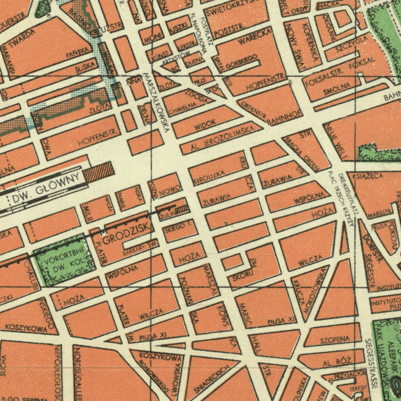
The map can be explored using both archival and contemporary plans of Warsaw, including a 1941 map showing the German street names introduced by the occupiers, as well as the marked boundaries of the ghetto. Available aerial photographs from, among others, 1935, 1945, and 2025 make it possible to trace how the places marked on the map have changed over time.
We have marked, with an “X” symbol, both places where Jews hid with the help of Poles and locations connected with Jewish self-help initiatives, as well as other sites associated, for example, with the activities of aid organisations such as the Jewish National Committee, the General Jewish Labor Bund, and the “Żegota” Council to Aid Jews.
We present these stories in an accessible, concise form, relying mainly on the accounts of the participants in the events themselves, which encourages the discovery of these “right addresses” while walking through the city.
More detailed historical studies, richly illustrated with photographs from the collections of POLIN Museum and supplemented with oral history testimonies, are available on the Polish Righteous Portal.
Explore the city with the historical map — discover Warsaw and the fate of its inhabitants
Today, Warsaw’s “right addresses” no longer stand out in the urban landscape, yet they conceal the dramatic stories of extraordinary people, their courage, empathy, and selfless devotion. We believe that, in the face of today’s wars and conflicts, these stories can serve as an inspiration for actions to support human rights, dialogue, and the search for what unites rather than what divides us.
⁂
The historical map The Right Address. Stories of Jews Hiding in Occupied Warsaw was created on the basis of the content of POLIN Museum of the History of Polish Jews virtual exhibition of the same title, developed in cooperation with the Warsaw blog Pańska Skórka, which premiered in the autumn of 2015.
A year later, the exhibition received a distinction in the Sybilla Museum Event of the Year competition, organised by the National Institute for Museums.
Ten years later, we transferred the exhibition to the Historical Portal of Warsaw, which enables users to explore its content through new, advanced functionalities and through integrating the map with the Polish Righteous Portal. In this new format, the exhibition’s content has been updated and expanded.
The historical map The Right Address will continue to be developed. In the coming months, we will add new locations, historical studies, and photographs from the collections of POLIN Museum.
Browse through the historical map: The Right Address — Stories of Jews Hiding in Occupied Warsaw [the Historical Portal of Warsaw] →
Creators (2015/2025):
- Project coordination and concept: Klara Jackl (virtual exhibition), Mateusz Szczepaniak (historical map)
- Text authors: Karolina Dzięciołowska, Klara Jackl, Mateusz Szczepaniak
- Academic consultation: Prof. Jolanta Żyndul, Prof. Artur Markowski, Adam Dylewski (virtual exhibition)
- Translation: Zofia Sochańska (English version available on the Polish Righteous Portal)
- Photographs: Klara Jackl, Olga Mielnikiewicz, Mateusz Szczepaniak
- Spatial data implementation: Monika Mazur
- We would like to thank the team of the Office of Geodesy and Cadastre of the Capital City of Warsaw – publisher of the Historical Portal of Warsaw
Bibliography (selected):
- Interviews with Righteous Among the Nations and Holocaust survivors, iconographic materials, and other digital resources from the collections of the POLIN Museum of the History of Polish Jews.
- Testimonies from the Archives of Yad Vashem in Jerusalem, ref. no. M.31.
- Testimonies from the Archives of the Jewish Historical Institute in Warsaw, ref. no. 349/24.
- This project made use of a 1941 map of Warsaw from the collections of the National Library of Poland (ref. no. ZZK 28 035). The map was published by Polnischer Verlag and produced by the Graphic Works of B. Wierzbicki & Co. in a Polish-German bilingual edition under the title Stadtplan von Warschau / Plan miasta Warszawy (Map of the City of Warsaw).
Read and see more:
- The attitudes of Poles toward Jews during the Holocaust [a thematic study] →
- The death penalty for helping Jews in Occupied Poland [a thematic study] →
- Poles and the Warsaw Ghetto Uprising [a thematic study] →
- Zofia Kossak’s appeal “Protest!” (1942) [a thematic study] →
- The “Żegota” Council to Aid Jews [thematic section] →
- Jews hiding on the “Aryan side” [thematic section] →
- Jews helping other Jews on the “Aryan side” [thematic section] →
- Educational film and discussion with experts about Irena Sendler and Jadwiga Piotrowska →
- Educational film and discussion with experts about Jan Żabiński and Antonina Żabińska →
- Interviews from POLIN Museum’s oral history collection [YouTube channel] →

